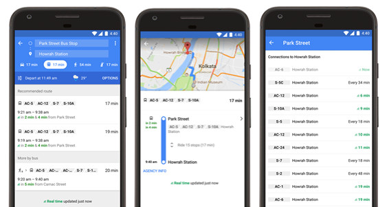
Google Maps already has transit feature in 16 Indian cities, today Google has announced a partnership with the West Bengal Transport Corporation (WBTC), to add real-time information about bus arrival times for Kolkata on Google Maps.
This is the first launch of real-time transit information for Google Maps in India. With the new feature, when you type the two locations into Google Maps to get info about bus – you’ll see when the next bus is actually arriving at your stop.
It also shows estimation of how long your trip is going to take, and if your bus is delayed it will automatically update the times in line with the new conditions. Arrival times based on real-time information available are marked in green on Google Maps.
You can also get real-time bus information by searching for a particular bus stop, tapping its name and its listed bus numbers. You will then see a listing of all buses arriving, with the location-enabled buses displaying their real-time ETA from the stop.
Google Maps real-time transit is now available for key WBTC transit routes in Kolkata, and will be expanded to the remaining routes in the future. Google said that it will continuesto work with public transport services in other cities to enable real-time transit information for their services.
Regarding the new feature, Narayan Swaroop Nigam, IAS, Managing Director, WBTC, said:
By sharing the real-time transit information of our buses with Google Maps, we are striving to deliver an enhanced level of service for our commuters. We are confident that the practical use of this technology will facilitate better trip planning resulting in greater convenience to commuters. We expect this to help increase the footfall in our buses and improve revenue realisation.
Sri Subhendu Adhikari, Minister In Charge Transport Department, Government of West Bengal, said:
This is yet another attempt to bring smart public transport to Kolkata and to improve the performance of WBTC. We are committed to improve public transport.
